
Using Satellite Imagery for Good: Detecting Communities in Desert and Mapping Vaccination Activities
Author Names:-Anza Shakeel, Mohsen Ali
Conference:-Arxiv 2017Publication Year:-2017
DOI:-arXiv:1705.04451
Un regularized and accelerated migrations are producing congestion among the cities hence increasing the unrestricted development of land. Semi-urban and agricultural lands are being consumed in order to accommodate the needs of growing population. Land development authorities and other activities (Mining, Grazing and Logging) are collectively modifying earth’s landscape. This is one of the reasons of Deforestation resulting in mass destructions made by floods. All such modifications, developments and activities needs to be observed and recorded. Satellite Images of an area in Lahore shows the extent with which construction has increased over the passage of time.


We are studying Satellite and Ariel Imagery in order to prevent and reverse desertification; we aim to automate the monitoring of these changes made by humans on land so that Governments can cater the problems of congestion; resource shortages; unemployment and infrastructure deficit. It is our vital need to manage our resources to have a better future. Apart from land degradation, we have witnessed disputes over territories and are going through War on Terror following massive destructions. All these terrible demolitions can be viewed and detected by studying aerial imagery of the affected areas. A satellite shot of Gaza clearly shows the after effects of war.
Primarily we have initiated to study these images in order to identify residential structures. We have successfully detected residential areas using computer vision technique such as machine learning, a texton based dictionary was learned by the SVM (Support Vector Machine). A texton dictionary was med by convolving the image with a filter bank and then Kmeans clustering is used to build the dictionary. A histogram of image patch is made based on the nearest texton in the dictionary, these histograms serves as a training model. Sample images show detection of structures in blue. We got these results using Google earth images which are freely available but obtaining these results from low resolution satellite imagery of Pakistan is a difficult task as compared to very high resolution imagery of other Developed Countries. Detection of residential structures is a first step in this research, as we are planning to count houses in these detected regions.

Using the prediction from our Model, this Visualization shows the Distribution of Built-Up Density in Punjab Province
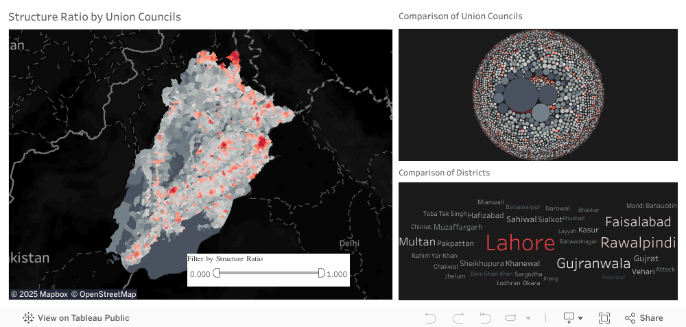
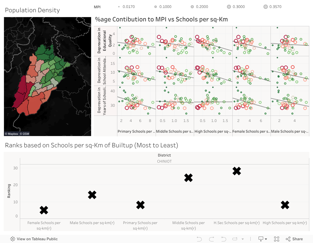
Different studies can be organized to initiate a research, opening gates for many fields that include classification of crops; detection of flood hit areas and prediction of degree of destruction; judging animal migrations; detection of roads to see connected and unconnected communities; detection of residential structures plus detection of skyscrapers. Likewise satellite images can be further studied in similar domain such that residential structures located in different areas can be detected and tagged, this will assist Government officials in multiple ways like; in conducting census, division of resources with respect to population density, CNIC verification and regularity of vaccinations.

Author Names:-Anza Shakeel, Mohsen Ali