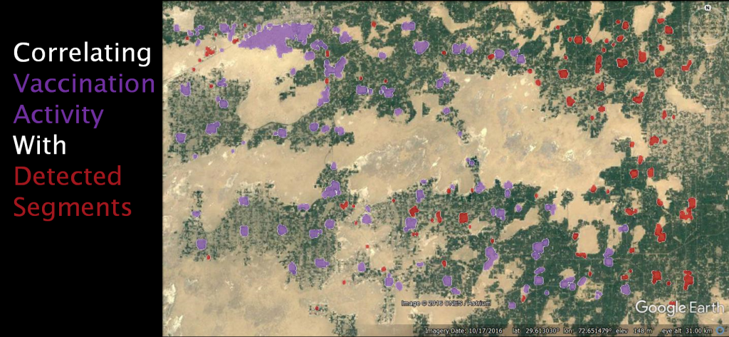
We at ITU are studying satellite and aerial imagery to develop tools that will assist Government and Non-Government organization in analyzing urban population, road structure, urban and rural structural development, agricultural regions, animal migrations and destruction caused by natural disasters. Primarily we have studied satellite and aerial images in order to detect residential areas using computer vision and machine learning techniques.
Economics From Afar
Artificial Intelligence, Economics, Satellite Imagery
WHO WE ARE
About Project

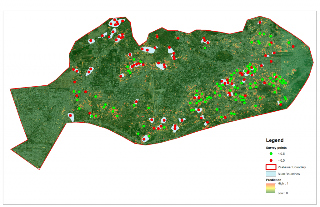
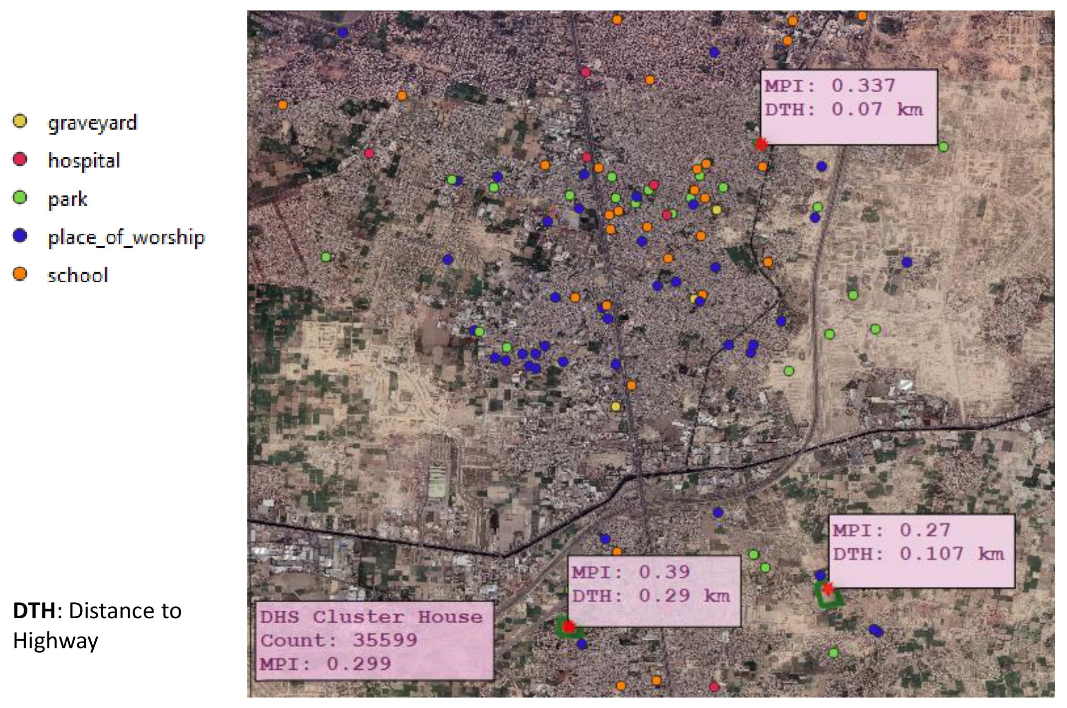
To overcome the challenges of lack of information and regular surveys, machine learning based satellite imagery algorithms have been proposed to predict the economic indicators of a region. These indicators (ranging from poverty estimation, slum detection) not only help government design policies but are vital tools for the businesses to understand their customers, design their business strategy and evaluate their business model. Unfortunately, these algorithms’ predictions are not interpretable and being based on homogeneity, they fail to generalize over the regions. Instead of popular black-box techniques, we plan to create an interpretable economic well-being analysis using satellite imagery and geo-spatial datasets (e.g. estimating the density of buildings, closeness to parks, population prediction, etc.) and solve the domain adaptation problem by constraining over the interpretation rather than just generic image or feature level adaptation.
Blogs


Core Team

Dr. Mohsen Ali
Principal Investigator
Assistant Professor, Department of Computer Science, Information Technology University

Dr. Izza Aftab
CO-Principal Investigator
Assistant Professor and Chairperson, Department of Economics.
Research Team

Shams Sadiq
Research Associate
Shams is a Research Associate at Intelligent Machine Learning Lab at Information Technology University Lahore (ITU). He holds a Master’s degree in Economics from Lahore University of Management Sciences. In his master’s thesis, he used GIS flood data and remote-sensing techniques to evaluate the Impact of Floods on Schools’ Performance in Punjab, Pakistan.
Sadaf Akbar
Research Associate
She is a professional with over four years of experience in research/policy analysis and holds a BS (Hons) with a major in Economics and minor in Psychology and an MPhil in Applied Economics. Her ongoing and planned research are in the fields of inclusive and sustainable development in Pakistan, institutions and development and urban economics.

Aliza Masood
Research Associate
A passionate researcher skilled in computer vision and remote sensing. Her research interests are Unsupervised Domain Adaptation, GIS, Semantic Segmentation and Topological Data analysis. Holds a Bachelor’s degree in Computer Science and is currently doing Masters in Data Science from ITU as well as working as a Research Associate at IML.

Nimra Dilawar
Ph.D. Fellow
A Ph.D. Fellow at Intelligent Machines Lab at Information Technology University (ITU) Lahore. She completed her Mphil and Bachelors in Computer Science from Kinnaird College for Women Lahore. Currently interested in working medical image processing
Sara Nadeem
Ph.D. Fellow
A Ph.D. student at Intelligent Machines Lab (IML), Information Technology University (ITU). Her research interests are in the areas of Computer Vision, Machine Learning and Deep Learning, focusing on Object Detection and Domain Adaptation.

Muhammad Haris
Graduate Fellow
A Graduate fellow at ITU Working as a Research Assistant at Intelligent Machine Lab. Hold a Bachelor’s Degree in Computer Science and currently doing MS in Data Science from ITU.Interested in Domain adaptation and Object Detection.
![]()
COLLABORATIONS

FUNDINGS